
Download Our Latest Whitepaper:
Operational and Capital Ecoservice Accounting Standards for Farm Carbon

A well-designed CEA can make a huge difference to the profitability of your carbon farming project. Still, many developers are unknowingly creating CEAs in ways that inflate costs and diminish potential carbon credit returns.

The topic of carbon estimation areas (CEAs) comes up frequently in conversations between our team members and clients. Understandable, since defining your soil carbon project's CEAs is one of the most important aspects of your soil carbon project when registering it with the Clean Energy Regulator (CER), and one that must be completed in advance of the baseline sampling round. Since poorly designed CEAs can negatively affect your project, we thought it would be worthwhile to dive a little deeper into them with a dedicated blog post.
The CER’s soil carbon method outlines what you can and can’t do when designing your CEAs, as well as their eligibility requirements. For further details on these requirements, see section 1.2 Land eligibility requirements in the CER’s Understanding your soil carbon project – Simple Method Guide. Whilst the method guide explains what you need to do to stay compliant, it doesn’t tell you how to design your CEAs in a way that maximises the profitability of your project. But don’t fret, we’re here to shed some light.
Speaking to both farmers and carbon project consultants, we’ve discovered that approaches towards designing projects and CEAs vary across the industry.
The intention of dividing a property into eligible CEAs is to define areas where new land management activities (activities that meet the newness or additionality requirements of that area, see 1.3 – Eligible management activities, Understanding your soil carbon project – Simple Method Guide) are being practised.
There have been reports of developers subdividing farms and registering multiple projects; artificially inflating the number of projects and CEAs on a project area.
Soil carbon projects are a 25 year or 100 year commitment. If, during this period, you are unable to manage the land as agreed or choose to sell it, the next person who inherits the land will need to continue the agreed upon land management practices until the permanence period is completed. An inability to do so means credits may need to be refunded; a reality that can be daunting for landholders at the time of deciding about how to proceed with a long–term project.
For this reason, some project developers advise to use CEAs to “parcel up” project areas in a way that the landholder is most likely going to divy up the land for future uses, say for sales or legacy purposes.
Whilst this might seem like a smart workaround for succession planning, by basing your CEAs on property sales or legacy plans, you may be inadvertently increasing sampling costs and potential for error in measurement, therefore reducing your potential future gains from carbon credits.
The important thing to understand about CEAs is that the more distinct CEAs you have, the more samples you need to take of your project area to achieve the same level of statistical confidence as you would have needed if you'd used just one CEA. To maximise carbon credits from a project, you need to optimise your statistical confidence in measurement.
By the way, It is possible to vary your project area after you’ve commenced your carbon project. Per guidance from the CER, you can submit a request to vary your project when the need for changing up your project area and CEAs actually arises.
As we’ve covered in our last blog post Measuring vs. Modelling for Soil Carbon Quantification, increasing your statistical confidence, in other words lowering your variance in measurement between two soil sampling rounds using geostatistics, is key when you’re trying to maximise your carbon farming returns.
Variance, or margin of error, refers to the percentage point that a derived value differs from the real value. It is exactly this difference between a measured/modelled value and the actual value, that vastly impacts the amount of carbon you derive from your carbon farming project; you want to make sure that what you’re predicting to sequester is as close as possible to what you actually are sequestering in an offset period.
As you can see in Figure 1 below, the more variance in measurement there is, the less statistical confidence you have, and thus the more carbon you leave behind in your carbon net abatement calculations and crediting period.
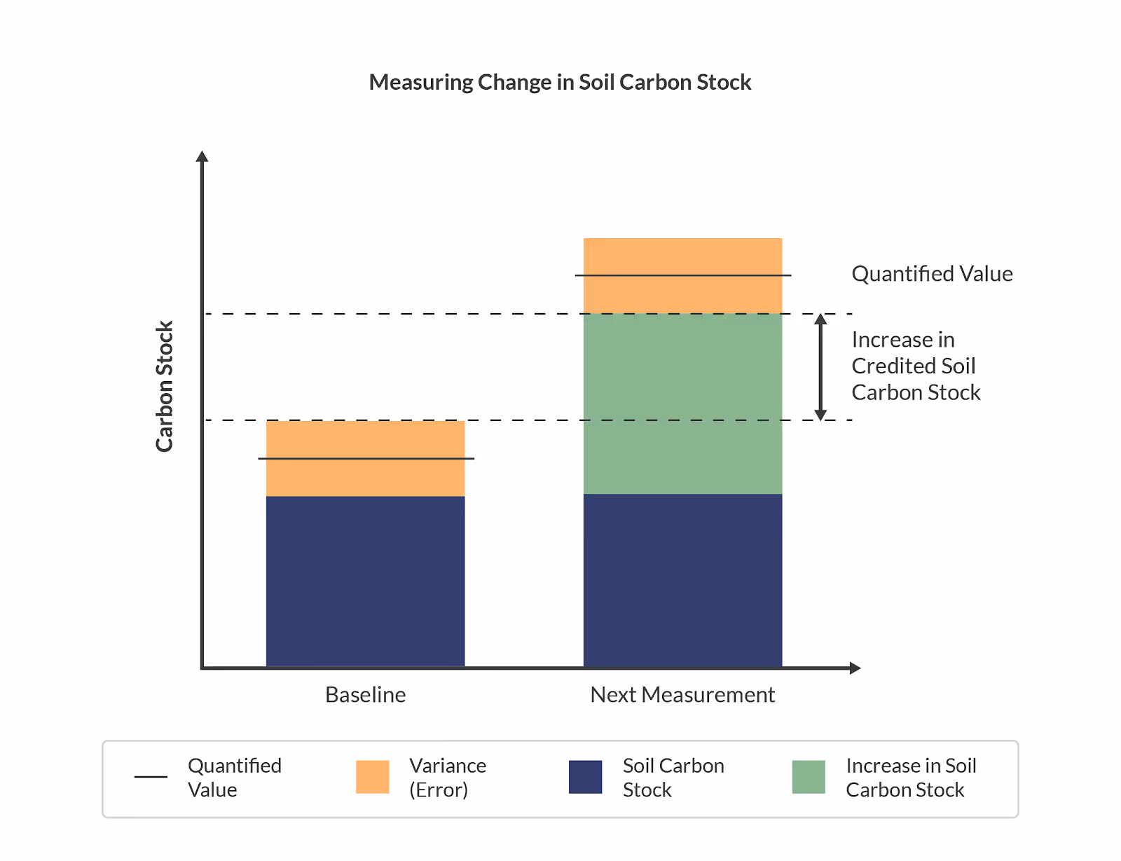
Figure 1: Measuring change in soil carbon stock and identifying the amount that can be credited. Source: Ryzo Pty Ltd.
By creating more CEAs than your project needs, you are also artificially inflating the number of samples you need to collect in order to remain compliant with the CER's methodology.
The Clean Energy Regulator’s soil carbon methodology (2021) requires at least 3 strata (groupings of areas which are common, for example based on soil type) per CEA and a minimum of 3 samples per strata; meaning you will need to take at least 9 soil samples per CEA in order to stay compliant with the methodology.
You have a 300 ha cattle farm in a high rainfall area, and would like to run a soil carbon project on it. After analysing your property you decide that there’s not much variation in the landscape and land usage, you decide to register a single CEA for your project area with the CER.
1 CEA with minimum of 3 Strata groupings * 3 samples per strata = minimum 9 soil samples
If you instead decide to break your project area up into 4 CEAs due to legacy or sales reasons, your minimum sampling requirement skyrockets up to a minimum of 36 samples, which drastically increases the cost of measuring this area. There is a cost associated with sampling, and the number of samples you take directly impacts your bottom line.
Instead of unfoundedly increasing the number of samples, you want to scientifically optimise your sampling plan using geostatistical calculations to determine how many samples are required for a given variance.
Smaller CEAs means that more samples are required to hit an equivalent level of statistical confidence. You actually want your CEAs as big as possible (where farming practices are common) to take advantage of geostatistical calculations used by the methodology.
The Ryzo Platform allows you to determine your CEAs and eligible land management practices, and to draw and edit your project boundaries with ease.
We recommend starting with the largest project area possible, typically the legal title. You can search by Lot/DP number or upload a kml file outlining the boundaries of the property directly into the Ryzo Platform.
Next, group your project areas by areas of common land management practices, for example grazing and cropping areas. Identify the practices in these areas that could be considered new or materially different from the current activity (refer to the additionality or newness factors outlined in the methodology) in this area that would result in increasing the amount of carbon stored in the soil, such as rotational grazing rather than continuous grazing. For optimal sampling plans, these areas should remain intact and large instead of being divided based on possible future sales. This way you will not be paying more over the next 25 years based on trying to plan for a possibility of selling property – the CER has guidelines on how to subdivide a project in the future.
Having defined the relevant areas, auto-exclusion tools within Ryzo will help you identify and exclude invalid areas, i.e. exclusion zones (areas that cannot be sampled, such as forests and water bodies). Additionally, you can use the cursor to manually exclude areas such as buildings and other areas that are associated with a different ERF methodology and cannot be included in the soil carbon project.
When you have completed your CEAs, create your cost-optimised sampling plan in the Ryzo Platform to prepare to conduct your baseline sampling. Using the patented FAAST algorithm, Ryzo determines the optimum number of sampling points for each CEA. Besides controlling error (variance) and minimising project costs, the platform ensures that only sampling points that are necessary are used to maximise return on investment. You can further customise your sampling plan to either maximise carbon credit returns or minimise costs.
By dividing your CEAs based on the possibility of land sales in the future, you may well be unintentionally increasing project costs and reducing carbon credits returns. While soil carbon projects can be hugely beneficial for your farm enterprise, they are also long-term investments requiring considerable time and resources, so it is vital to get them right the first time. Let us help you turn your soil carbon project into a success.
If you would like to speak to someone from our team about designing CEAs that will maximise your profits, feel free to email us via helpdesk@ryzo.earth

Sign up to the Ryzo Newsletter and discover how you can improve farm production whilst benefiting from the new income stream the carbon trading market has to offer.
